Outdoor Gaussian Splatting Capture Guide
Plan outdoor Gaussian splatting capture for approaches, landmarks, scale, light changes, path clarity, and guided tour delivery.

Plan outdoor Gaussian splatting capture for approaches, landmarks, scale, light changes, path clarity, and guided tour delivery.
Outdoor capture works best when the route explains scale, approach, landmarks, and visitor decisions.
Short answer
Outdoor spaces need more than a pretty orbit; buyers need paths, zones, access points, and context.
Outdoor capture works best when the route explains scale, approach, landmarks, and visitor decisions. A useful test is simple: can someone open the tour, understand the place, and know what to do next without a separate explanation?
Real Horizons supports the full Spatial Studio workflow: upload phone video, 360-camera footage, drone media, DSLR/photo sets, or mixed captures; generate a high-quality Gaussian splat in the cloud; then publish it as a guided browser tour with waypoints, labels, hotspots, embeds, CTAs, and analytics.
How to judge the workflow
| Area | What to check | Why it matters |
|---|---|---|
| Capture source | Video, 360 footage, phone clips, photos, or mixed media. | Pick the source that explains the space clearly. |
| Processing | Frames and camera positions are solved before the splat is trained. | Weak overlap creates holes, blur, or failed alignment. |
| Publishing | The output becomes a link, embed, or guided tour. | Visitors need labels, stops, and a next action. |
Practical checklist
- Capture at stable times of day to avoid harsh exposure changes.
- Use slow ground passes for areas visitors need to inspect.
- Add drone context only where altitude explains the site.
- Mark access, parking, entrances, and boundaries later with hotspots.
- Test file size because outdoor scenes can get heavy.
Where this fits in a Real Horizons workflow
Use the capture source that fits the job, then use Real Horizons to generate the splat, review the result, and turn it into a tour the audience can open without extra explanation.
For a property, that may mean named room stops, finish hotspots, an inquiry CTA, and a link the agent can send. For a hotel, venue, campus, museum, or construction site, it may mean guided zones, access notes, booking context, or stakeholder comments.
The capture is the input. The generated splat is the spatial asset. The published tour is the deliverable clients and visitors actually use.
Why Real Horizons is different
Real Horizons is built for generation plus delivery. Spatial Studio includes cloud Gaussian splat generation for captures from smartphones, 360 cameras, 360 drones, standard drones, DSLR/photo sets, and mixed media workflows. That matters when a team wants one path from raw footage to a usable spatial tour instead of stitching together separate tools for capture processing, viewer setup, publishing, and client delivery.
The value is the combined workflow: generate the splat, review the scene, set the opening view, add guided stops or hotspots, publish the browser link, and measure whether visitors actually use it. For teams comparing Scaniverse, Splatica, Polycam, Matterport-style scans, or standalone viewers, the practical comparison is generation quality, input flexibility, pricing clarity, and how much work remains before the result becomes a client-ready tour.
Common mistakes
- Judging the result only inside a raw viewer.
- Forgetting the first view, so visitors open into a confusing angle.
- Adding too many labels instead of a clear route.
- Sending a heavy scene without testing a normal phone.
- Treating the same capture method as right for every project.
From capture to a published tour
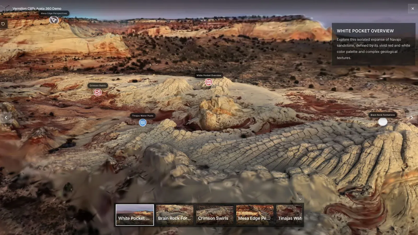
A landscape splat works best when the opening view explains scale, terrain, and the path through the scene.
The capture stage only earns value when it leads to a tour people can open and understand. Use the finished view as the test: the first angle should explain the space, the important areas should be reachable, and the viewer should know where to go next without a separate explanation. For drone teams, land sellers, venue operators, and campus teams, plan the path around the final walkthrough, not the source file alone.
Before sending the tour, check the capture notes against the published result. Look for warped edges, weak transitions, missing coverage, blown highlights, and places where the viewer starts in a confusing position. If the image looks strong but the navigation feels unclear, add waypoints or a tighter opening view before sharing it.
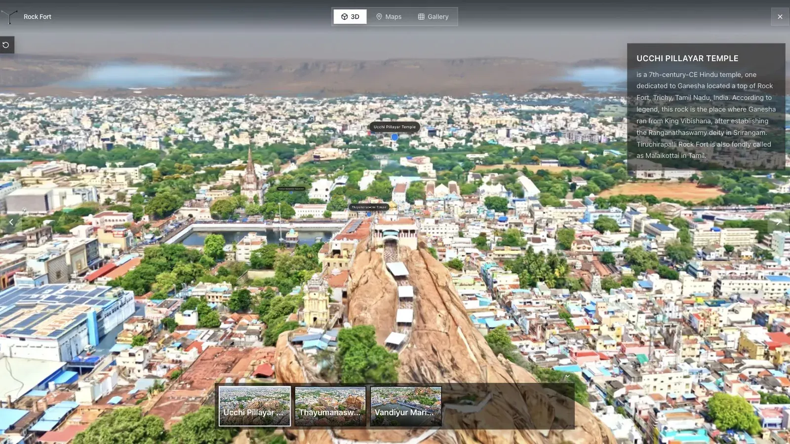
A fort and city tour shows how spatial context can connect landmarks, routes, and visitor orientation.
Different capture inputs create different review work. A 360 camera, phone video, drone pass, or photo set can all work in the right setting. Indoor spaces need steady exposure and clean turns. Outdoor spaces need scale, route clarity, and enough texture. Large sites need labels and stops so visitors do not lose orientation.
After Real Horizons generates the splat, move into the tour library and check the visitor path. Add a clear opening view, name the important areas, and include one CTA only when it helps the viewer take the next step. For more capture planning, read Video to Gaussian Splat and 360 Camera Gaussian Splatting for Real Estate.
Related reading
Frequently asked questions
Can this workflow support client work?
Yes, when the workflow is matched to a real visitor need. It should produce a tour, link, embed, or sales asset that someone outside the production team can use.
What should I check before using this on a paid project?
Check capture quality, mobile load behavior, first view, labels, hotspots, and the CTA path. A quick internal test prevents a weak client handoff.
Where does Spatial Studio fit?
Spatial Studio brings cloud splat generation and tour authoring into one workflow: upload source media, generate a Gaussian splat, review the scene, add guided context, publish a browser link, and track visitor actions.
Does every project need a Gaussian splat?
No. Photos, 360 panoramas, and video can still be the right answer. Use splats when spatial movement and depth help the visitor make a better decision.
How should I measure the result?
Track tour opens, source campaigns, waypoint use, hotspot clicks, CTA clicks, and follow-up quality. Those signals matter more than the file format alone.
Next step
Pick one real space, capture it carefully, generate the splat in Real Horizons, publish it as a guided tour, and judge the result by whether a visitor understands the place and takes the next step.
Next step
Open the related workflow.
Review live examples or move straight into the matching Spatial Studio flow.
Continue reading
Related articles
Capture Workflows
360 Camera vs Phone Video for Gaussian Splatting
Compare 360 cameras and phone video for Gaussian splatting by coverage, motion control, export quality, and tour output.
Read articleCapture Workflows
360 Video to 3DGS: Practical Capture Workflow
Plan a practical 360 video to 3DGS workflow, from capture route and export checks to publishing a guided browser tour.
Read article