3D Map Tours for Land and Plot Sales
Use 3D map tours for land and plot sales to connect drone context, plot availability, access, landmarks, and buyer decisions.

Use 3D map tours for land and plot sales to connect drone context, plot availability, access, landmarks, and buyer decisions.
Land sales content should connect maps, drone context, plot availability, and guided site understanding.
Short answer
Land buyers often need orientation before they need another brochure.
Land sales content should connect maps, drone context, plot availability, and guided site understanding. A useful test is simple: can someone open the tour, understand the place, and know what to do next without a separate explanation?
Real Horizons supports the full Spatial Studio workflow: generate high-quality Gaussian splats from smartphone video, 360 cameras, 360 drones, standard drones, DSLR/photo sets, or mixed captures, then turn the result into a guided browser tour with waypoints, labels, hotspots, embeds, CTAs, and analytics.
How to judge the workflow
| Area | What to check | Why it matters |
|---|---|---|
| Audience question | What does the buyer, guest, visitor, or stakeholder need to understand? | The tour should answer that first. |
| Tour structure | Use stops, labels, and hotspots around real decisions. | Avoid turning the page into a technical demo. |
| Business action | Connect the tour to inquiry, booking, leasing, or sales follow-up. | Measure activity after the link is shared. |
Practical checklist
- Show access, roads, boundaries, and amenities.
- Connect plot cards to visual context.
- Use drone or splat media where it explains terrain.
- Add inquiry actions for selected plots.
- Track which plots and zones get attention.
Where this fits in a Real Horizons workflow
Use the capture source that fits the job, then use Real Horizons to generate the splat, review the result, and turn it into a tour the audience can open without extra explanation.
For a property, that may mean named room stops, finish hotspots, an inquiry CTA, and a link the agent can send. For a hotel, venue, campus, museum, or construction site, it may mean guided zones, access notes, booking context, or stakeholder comments.
The capture is the input. The generated splat is the spatial asset. The published tour is the deliverable clients and visitors actually use.
Why Real Horizons is different
Real Horizons connects cloud splat generation with guided tour publishing. Spatial Studio supports captures from smartphones, 360 cameras, 360 drones, standard drones, DSLR/photo sets, and mixed media workflows. That matters when a land-sales team wants one path from drone, site, plot, or mixed capture to a usable map-led tour instead of stitching together separate tools for processing, viewer setup, publishing, and buyer follow-up.
The value is the combined workflow: generate the splat, review the scene, set the opening view, add guided stops or hotspots, publish the browser link, and measure whether visitors actually use it. For teams comparing Scaniverse, Splatica, Polycam, Matterport-style scans, or standalone viewers, the practical comparison is quality, input flexibility, pricing, and how much work remains before the result becomes a client-ready tour.
Common mistakes
- Judging the result only inside a raw viewer.
- Forgetting the first view, so visitors open into a confusing angle.
- Adding too many labels instead of a clear route.
- Sending a heavy scene without testing a normal phone.
- Treating the same capture method as right for every project.
Commercial packaging example
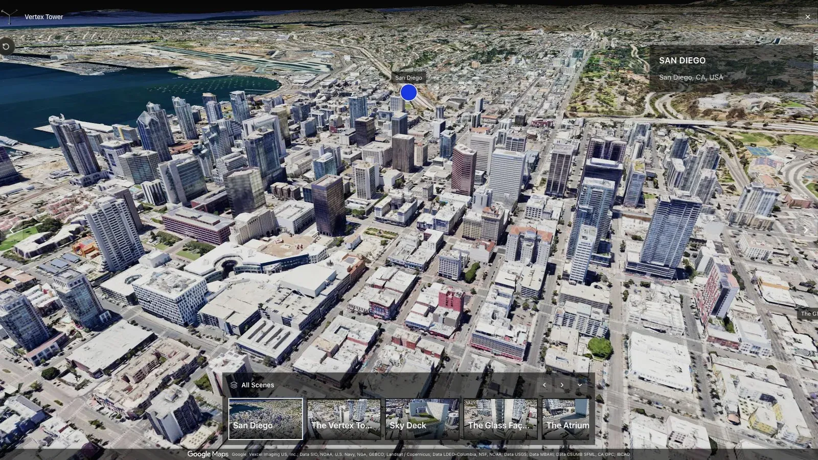
A city-scale map tour gives large sites the context that a room-by-room viewer cannot provide alone.
For this use case, the important question is what the tour helps a buyer compare. Land buyers may need plot availability, road access, boundaries, amenities, slope, neighboring context, and a reason to shortlist one parcel over another. For land sellers, developers, and sales teams, the tour should make those comparisons easier within the first few seconds.
The published page should make the tour easy to identify, open, and share. Use a strong first image, plain labels, a short description, and one next action that matches the buying or planning moment. If the scene is large, lead with orientation. If it is interior-led, lead with the room, amenity, or feature people came to inspect.
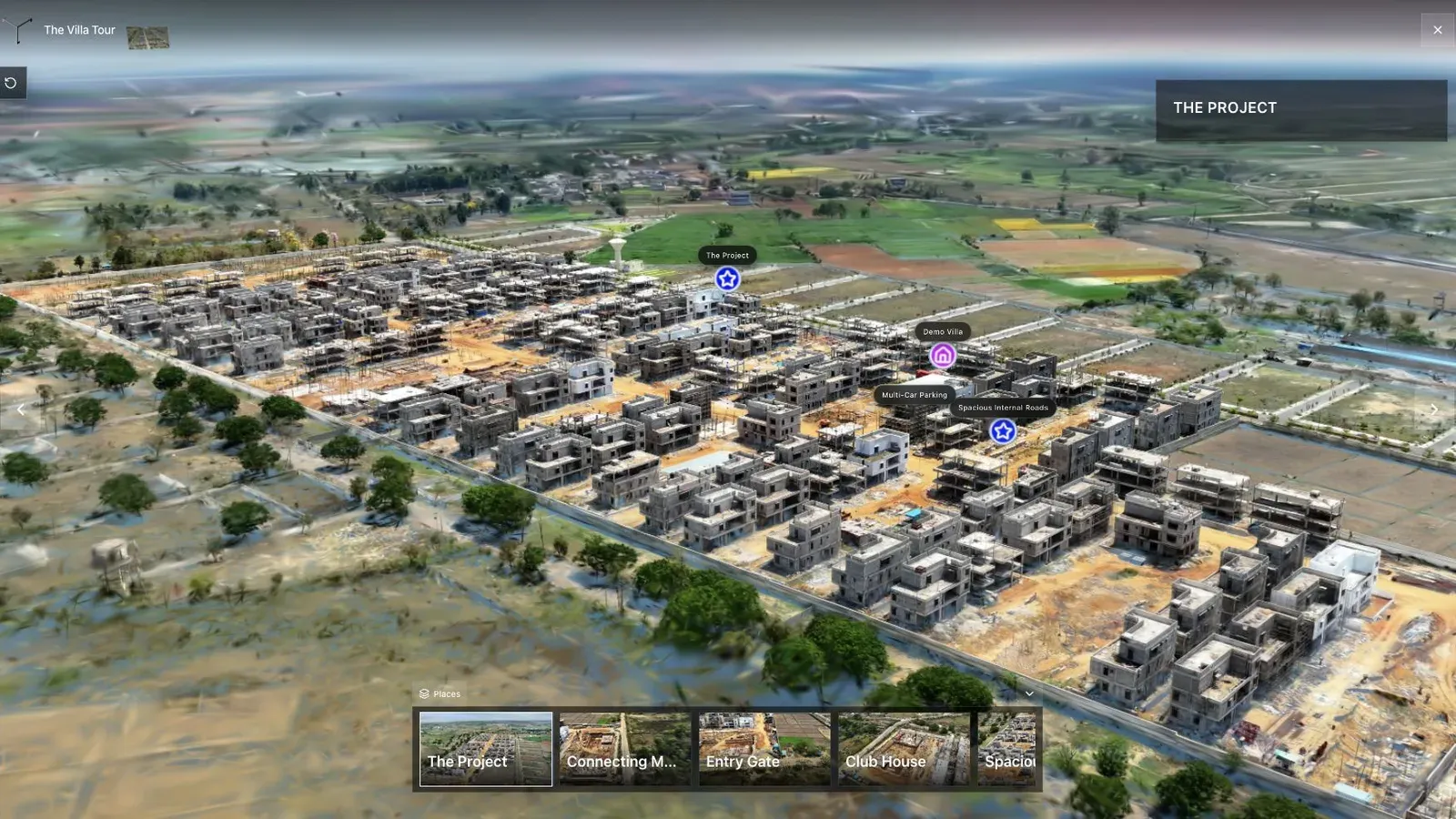
A land-development tour combines aerial context, waypoints, and site detail in one published view.
Larger commercial spaces often need more than one media mode. A resort may need an aerial overview and amenity stops. A land project may need map context and construction progress. A museum or heritage site may need guided interpretation. Use labels and stops to explain zones instead of forcing visitors to discover everything by wandering.
Before launch, decide where the link will be placed, who should open it, what action counts as interest, and when the team will review performance. For the broader tour workflow, read Splat Virtual Tour Software and Gaussian Splatting for Real Estate.
Related reading
Frequently asked questions
Can this workflow support client work?
Yes, when the workflow is matched to a real visitor need. It should produce a tour, link, embed, or sales asset that someone outside the production team can use.
What should I check before using this on a paid project?
Check capture quality, mobile load behavior, first view, labels, hotspots, and the CTA path. A quick internal test prevents a weak client handoff.
Where does Spatial Studio fit?
Spatial Studio brings cloud splat generation and tour authoring into one workflow: upload source media, generate a Gaussian splat, review the scene, add guided context, publish a browser link, and track visitor actions.
Does every project need a Gaussian splat?
No. Photos, 360 panoramas, and video can still be the right answer. Use splats when spatial movement and depth help the visitor make a better decision.
How should I measure the result?
Track tour opens, source campaigns, waypoint use, hotspot clicks, CTA clicks, and follow-up quality. Those signals matter more than the file format alone.
Next step
Pick one real space, capture it carefully, generate the splat in Real Horizons, publish it as a guided tour, and judge the result by whether a visitor understands the place and takes the next step.
Next step
Open the related workflow.
Review live examples or move straight into the matching Spatial Studio flow.
Continue reading
Related articles
Commercial Use Cases
3D Tours for Campuses and Public Spaces
Plan 3D tours for campuses and public spaces with landmarks, routes, access notes, zone labels, and browser sharing.
Read articleCommercial Use Cases
Commercial Real Estate Virtual Tours for Leasing
Create commercial real estate virtual tours for leasing with access, frontage, fit-out, amenities, guided stops, and inquiry CTAs.
Read article